
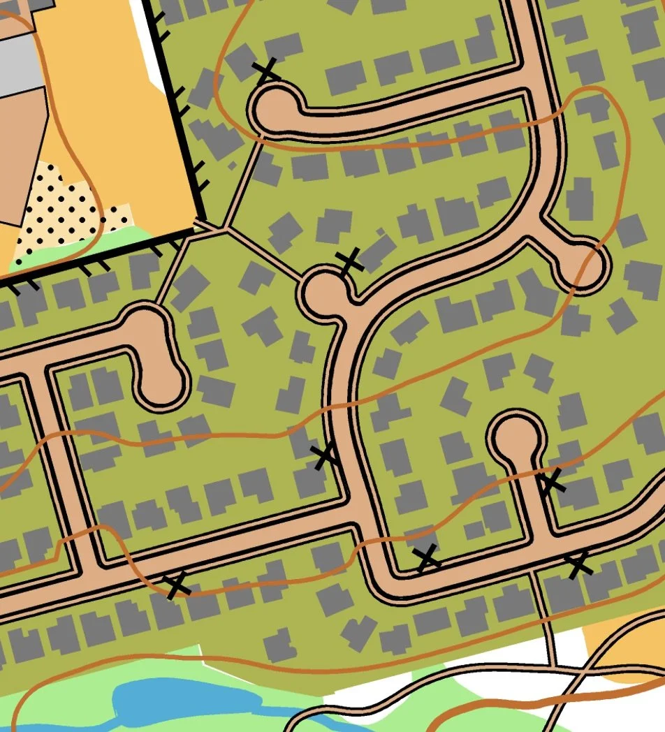
Sexton Mountain map example
ADVANCE ONLINE REGISTRATION IS REQUIRED FOR THIS EVENT.
Makes things fast and easy for YOU on event day (no paperwork or payment)
Simplifies processing the results
Helps meet directors know how many maps to print
See who’s attending, maybe plan a carpool
Quick info
Courses: Four different courses for all skill levels. Score-O format; find as many controls as possible in any order within the time limit.
TImes: Check in begins at 10:30 and the beginner clinics occur at 11:00 and 11:30. Start your course anytime between 11:00 AM and 1:00 PM. Courses close at 4:30 PM.
Everyone welcome, members and nonmembers
Event director/Course Setter: Tony Pinkham
EVENT OVERVIEW
Need to run or walk off a few calories from your Thanksgiving feast? Here's your chance! The newly expanded Sexton Mountain map of Beaverton offers over 8 square kilometers of hilly residential neighborhoods with lots of streets going in non standard directions and lots of walkways through green spaces and connecting neighborhoods. Anyone wanting to minimize their hilly experiences can do the short course, which lets you stay close to the start/finish where the hills are not so steep. Anyone needed to burn calories can do a longer course with lots of hills to meet your demanding needs. This event happens rain or shine (if it snows, you can use your XC rock skis).
Each control on your map has an identifying number. The first digit of the control number shows the point value of that control (for example, control 31 is worth 3 points and control 51 is worth 5 points). To show that you found a control, you answer the question for that control on a Question & Answer (Q&A) sheet that you carry with your map. Answer the question correctly (the questions are easy), you get the points for that control. Answer it incorrectly, we assume you guessed and you lose the number of points for that control. Don't guess.
We will have four courses using the same course map. The courses have maximum times of 1 hour, 2 hours, 3 hours, and 4 hours. You specify your preferred course time limit when you finish. If you finish past the time allowed for your course, you lose a point for each minute or fraction of a minute that you are late. It pays not to be late.
You get to decide whether you are a competitor or recreational map hiker. Competitors get their times and scores published. Recreational map hikers get honorary mention for doing the course without mention of points or times. Competitors and recreational map hikers can go as individuals or teams. Competitive teams must stay together at all times (no splitting up to find controls). Everybody has to check into the finish by 5:00 PM so that we know that everyone has returned safely.
Stay off of private property (shown as olive green on your maps) at all times. Public schools with open gates can be accessed.
When you arrive for this event, go to the check in station to receive your Q&A sheet and then go to either the beginner clinics (if you are new to orienteering) or to starts (if you are ready to orienteer). When you are ready for a start time, show your Q&A sheet to the starter to get a start time. When your start time occurs (this happens each minute or each two minutes), pick up your map and begin your course (one map per person on your team). When you finish or quit your course, bring your Q&A sheet to the finish station and hand it in. Your finish time occurs when you turn in your Q&A sheet. Both the starts and finishes occur next to each other.
If possible, we will post our results at the event. In the event of inclement weather, results will be posted a day after the event.
NEW TO ORIENTEERING? WELCOME!
Our events are open to both members and non-members, and beginners are welcome.
Have a look at our “New to O?” webpage, which covers just about every question you may have.
You can compete as an individual or as a team. Maximum team size is six people.
At most events, we offer free beginner clinics (about 10 minutes) to teach you everything you need to know. These are typically at 30 minute intervals. If you'd like to attend, choose a time slot when you register.
If you'd like to get reminders about upcoming events, sign up at our newsletter page. (No more than a couple of emails per month, we promise!)
Thanks for coming out and trying something new, we think you'll like it!
Courses
All courses use the same map. They differ only by the amount of time that you spend looking for controls.
60 minutes: Probably the easiest course because it is shorter and uses flatter areas close to the start/finish.
120 minutes: More challenging because you are bound to venture into some steep hills.
180 minutes: Challenging as you'll probably visit all of the steep hills in your quest to find them all.
240 minutes: Very challenging as you'll probably visit all the steep hills and new areas of the map.
TIMES
Beginner clinics: 11:00 am and 11:30 am. Choose your preferred time when you register.
Course starts: start windows between 11:00 am and 1:00 pm.
All courses close: 5:00 pm. If you do a 4-hour course, consider starting by 12:30 PM so that you are sure to be done by 5:00 PM even if you are late
(All teams must check out through the course finish area before leaving, even if you or your team does not finish the course or returns after the course closes. This way we know that everyone has returned safely.)
REGISTRATION AND OTHER COSTS
Advance online registration is required. There is no event day registration.
Application deadline: Thursday, February 9, 11:00pm
Event Cost
$12 base price - individuals
$17 base price - teams of 2 or more (maximum team size is 6)
- Subtract $5 for membership in CROC or other O-club - Become a CROC member
VOLUNTEERS
All CROC events are put on by volunteers, and the meet director can almost always use some extra hands. Please keep in mind:
No prior experience is needed for many of the tasks
You can help out AND still run your course of choice
Typical ways to assist are: helping with starts and finishes, checking in folks at registration, helping with results, and picking up control streamers after the course closes. Typical shifts are 60 to 90 minutes long.
If you'd like to help, please choose a volunteer slot when you register online.
RESULTS
We hope to post results on the Events & Results web page within a day or two after the event.
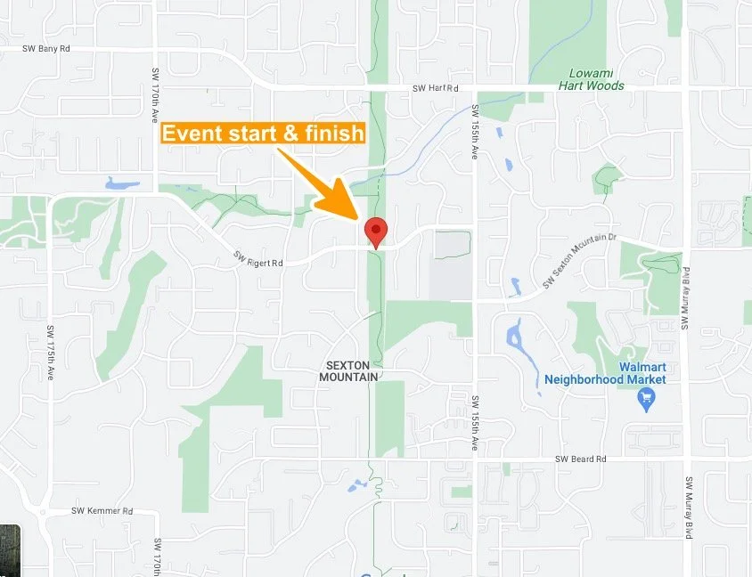
MAP AND DIRECTIONS
45.4602, -122.8411
Copy/paste these latitude longitude coordinates into Google maps or your smartphone mapping app to get a map and driving directions to the event.
Check in, starts, and finishes will be run at Hart Meadows park. Parking is on SW Rigert Rd. where it goes through Hart Meadows park.
Try a Google maps search for “Hart Meadows tennis courts”
To get to Hart Meadows Park bu car:
Take Highway 217 to SW Allen Blvd (exit 2B).
Go west on SW Allen for 1.7 miles to SW Murray Blvd.
Turn left onto SW Murray Blvd. and go 0.8 miles to SW Hart Rd.
Turn right onto SW Hart Rd. and go 0.5 miles to SW 155th Ave.
Turn left onto SW 155th Ave. and go 0.3 miles to SW Rigert Rd.
Turn right onto SW Rigert Rd. and go 0.2 miles to Hart Meadows park.
Park on the street.
Look for the orange and white “sandwich board signs when you get close.
To get to Hart Meadows Park by bus, take the 88 bus from the Beaverton Transit Center and get off at Hart Meadows Park (the stop after the SW 152nd Ave on Hart Rd).