Advance online registration is required for this event
Makes things fast and easy for YOU on event day (no paperwork or payment)
Simplifies processing the results
Helps meet directors know how many maps to print
See who’s attending, maybe plan a carpool
Quick info
Courses: Fice different courses for all skill levels. Classic point-to-point orienteering format.
TImes: Map handout opens at 10:30. Start your course anytime between 11:00 am and 1:00 pm
Everyone welcome, members and nonmembers
Event director: Mike Holliday and Mike Reid
EVENT OVERVIEW
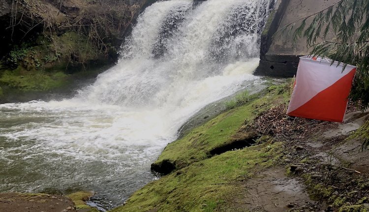
Welcome to the Lacamas Lake Park orientering meet! Lacamas Park is a large wooded area near Camas, WA. The park is hilly, with a complex network of canyons and spurs. Cliffs and rock outcrops are abundant.
There is an extensive trail network. Open rocky areas showcase wildflowers; however most of the vegetation is lush, and trail running skills will come in handy. Route choices for all courses are primarily on trail.
Note that there is poison oak in the park. Long pants and/or gaiters are recommended for the advanced courses.
We use an electronic scoring and timing system known as e-punch. Each entry or team needs to have an e-punch stick. If you don't have your own e-punch stick, the rental cost is included in your registration fee. Using e-punch is easy. You can learn how at the event, or read about e-punch here.
CROC thanks our land management partner Lacamas Park.
NEW TO ORIENTEERING? WELCOME!
Our events are open to both members and non-members. Beginners, families and dogs are welcome.
Have a look at our “New to O?” webpage, which covers just about every question you may have.
At most events, we offer free beginner clinics (they take about 10 minutes) to teach you everything you need to know. These are typically at half-hour intervals; choose your time slot on the registration page.
If you'd like to get reminders about upcoming events, sign up at our newsletter page. (No more than a couple of emails per month, we promise!)
Thanks for coming out and trying something new, we think you'll like it!
START WINDOWS
For this event we’re using assigned 30 minute start windows between 11 AM and 1 PM. This spreads participants over the entire two hour start window instead of a big rush at the beginning, encourages social distancing. and eases the workload on event volunteers.
Please choose your start window during registration. The earlier you register, the better chance you have of a preferred window. If you arrive early for your start window, you may be asked to wait. If you're late, no worries, we’ll allow you to start when we have an opening. It's a guideline, not a firm rule.
Intermediate Workshop for CROC Members:
Matching Map to Terrain: Map Symbols and Keeping in Touch with the Map
This no-cost workshop for CROC members will train people to understand the map symbols and to navigate through an intermediate course. We’ll work together as a group and do a “walk-about” observing features in the park. We’ll be done by 11:00 am with plenty of time for you to do a course.
TIMES
Member training, 10 AM to 11 AM, see above.
Beginner clinics: 11:00 am and 11:30 am. Choose your preferred time when you register.
Course starts: start windows between 11:00 am and 1:00 pm
All courses close: 3:00 pm (controls will be picked up)
(All teams must check out through the course finish area before leaving, even if the team does not finish the course or returns after the course closes.)
COURSES
White: Beginner (about 1.6 km, 12 controls, on-trail and near-trail navigation)
Yellow: Beginner / Intermediate (about 2.3 km, 12 controls, on-trail and near-trail navigation)
Orange: Intermediate (about 3.5 km, 12 controls, 105 m climb)
Brown: Short Advanced (about 3.6 km, 11 controls, 75 m climb)
Green: Long Advanced (about 5.1 km, 17 controls, 125 m climb)
Course Setter's Notes (Amy Winston)
The thick vegetation in the park requires course route choices to be primarily on trails. The Park has closed a trail to the lower falls to replace a damaged footbridge. The courses have been designed to avoid the trail closure and still provide plenty of orienteering challenge and fun. There is some climb and some steep slopes on the Orange, Brown and Green courses, but the climb is not excessive.
Here is the link to the Livelox GPS track visualization tool https://www.livelox.com/Events/Show/125100/CROC-Lacamas-April-2024 for Lacamas. It will go live at 4:00 PM on the event day. Everyone who can record a GPS track on their personal device is encouraged to upload their track (see below for more information).
REGISTRATION AND OTHER COSTS
Event Cost
$17 base price - individuals
$22 base price - groups of 2 or more
- Subtract $5 if you’re a member or CROC or other O-club (Join CROC)
- Subtract $5 if you have your own e-punch (Buy your own epunch)
LIVELOX: GPS TRACKING AND ROUTE REVIEWING TOOL
CROC uses Livelox, which is an interactive web based tool that enables you to see your exact route/track on the orienteering map, and compare them with other competitors.
By seeing the routes other people took, where you went, and where things went good or bad for you, you can learn and become a better orienteer.
To use this tool, you need to record a GPX track while you are on the course. This can be done with many phone apps and GPS watches. After the event, you can log into your free account, upload your track, and review your course.
See a link to the Livelox tracks from the Results page.
Questions? Email John Crowther
VOLUNTEERS
All CROC events are put on by volunteers, and the meet director can almost always use some extra hands. Please keep in mind:
No prior experience is needed for many of the tasks
You can help out AND still run your course of choice
Typical ways to assist are: helping with starts and finishes, handing out maps, and picking up control flags after the course closes. Typical shifts are one hour.
If you'd like to help, you can choose a task and time shift when you register online. Thanks!
RESULTS
Results are posted to the Events & Results web page a day or two after the event.
DRIVING DIRECTIONS AND LOCATION
The park area is north of Camas, WA; on the east side of Washington SR 500/SE Everett Rd. PLEASE PARK IN THE OVERFLOW PARKING LOT. This lot is reached by driving over the bridge between Round Lake and Lacamas Lake, turning right on 35th Ave, then left into the large gravel lot. Start is across street. Restrooms - walk south across the pedestrian bridge to the restroom building. See map below.
Look for the orange and white “sandwich board signs when you get close.
Note: There is a new TRAFFIC CIRCLE near the park entrance, please use caution.
Latitude longitude coordinates of the event:
45.6055, -122.4058
Copy/paste these latitude longitude coordinates into Google maps or your smartphone mapping app to get a map and driving directions to the event.